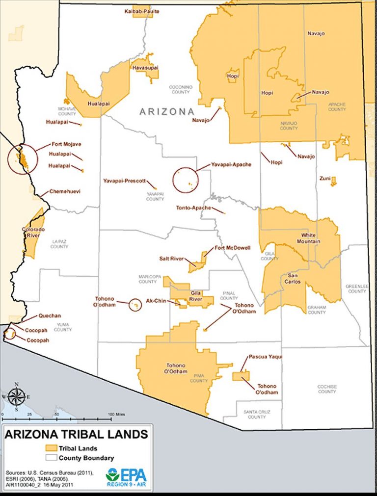
There are 24 indian reservations in the state of Arizona.
Arizona Indian Reservations
The Ak Chin Indian Community of the Maricopa (Ak Chin) Indian Reservation is a Native American community located in the Santa Cruz Valley in Arizona. The Ak Chin Community is composed mainly of Akimel O’odham and Tohono O’odham, as well as some Hia-Ced O’odham members.
The Camp Verde Indian Reservation(Yavapai-Apache Nation Indian Reservation) is home to the Yavapai-Apache Nation. Tribal members share two culturally distinct backgrounds and speak two indigenous languages, the Yavapai language and the Western Apache language.
In March 1875, the government closed the Yavapai-Apache Camp Verde Reservation, and marched the residents 180 miles (290 km) to the San Carlos Apache Indian Reservation. More than 100 Yavapai died during the winter trek.
By the early 1900s, Yavapai were drifting away from the San Carlos Reservation, and were requesting permission to live on the grounds of the original Camp Verde Reservation. In 1910, 40 acres (161,874 m2) was set aside as the Camp Verde Indian Reservation, and in the following decade added 248 acres (1,003,620 m2) in two parcels, which became the Middle Verde Indian Reservation. These two reservations were combined in 1937, to form the Yavapai-Apache Nation of the Camp Verde Indian Reservation tribe.
Today, the reservation spans 665 acres (2.7 km2), in four separate locales. Tourism contributes greatly to the economy of the tribe, due largely to the presence of many preserved sites, including the Montezuma Castle National Monument. The Yavapai-Apache Nation is the amalgamation of two historically distinct Tribes both of whom occupied the Upper Verde prior to European invasion. The Tonto Apache, calling themselves Dilzhe’e, utilized the lands to the north, east and south; while the Wi:pukba’ or Northeastern Yavapai were using country to the north, the west and the south. It was the Upper Verde where they overlapped.
The reservation consists of four non-contiguous parcels of land located in three separate communities in eastern Yavapai County. The two largest sections, 576 acres (233 ha) together – which comprise almost 90 percent of the reservation’s territory, are in the town of Camp Verde. Smaller sections are located in the town of Clarkdale 60.17 acres (24.35 ha), and the unincorporated community of Lake Montezuma (5.8 acres (2.3 ha)). The total resident population of the reservation was 743 persons as of the 2000 census. Of these, 512 lived in Camp Verde, 218 in Clarkdale, and only 13 in Lake Montezuma.
The Cocopah Indian Reservation is the reservation of the federally recognized Cocopah Indian Tribe.
The Colorado River Indian Reservation straddles a part of the Arizona and California border.
The 2000 census indicated a resident population of 9,201 persons, of which 3,389 were enrolled tribal members from the Chemehuevi, Mohavi, Hopi and Navajo tribes, which today, collectively form a geopolitical body known as the Colorado River Indian Tribes.
The Fort Apache Indian Reservation in Arizona is home to the White Mountain Apache Tribe, a Western Apache tribe which includes Arivaipa, Chiricahua, Coyotero, Mimbreño, Mogollon, Pinaleño, and Tsiltaden.
Acres: 1,681,920
Established by: Executive orders, Nov. 9,1871, July 21, 1874, Apr. 27 l876, Jan. 26 and Mar. 31, 1877; act of Feb. 20,1893 (XXVII, 469); agreement made Feb. 25, 1896, approved by act of June 10, 1896 (XXIX, 358), supplemented by act of June 7, 1897 (XXX,64).
The Fort McDowell Yavapai Nation, formerly the Fort McDowell Mohave-Apache Community of the Fort McDowell Indian Reservation, is a federally recognized tribe and Indian reservation in Maricopa County, Arizona about 23 miles (37 km) northeast of Phoenix, currently encompassing only 24,680 acres (100 km2) out of the much larger area that was originally Yavapai territory. The reservation was originally established in 1890 and is now home to approximately 971 people, mostly Yavapai (Mohave Apache).
The Fort Mojave Indian Reservation is an Indian reservation along the Colorado River, currently encompassing 23,669 acres (96 km²) in Arizona, 12,633 acres (51 km²) in California, and 5,582 acres (23 km²) in Nevada. The reservation was originally established in 1870 and is now home to approximately 1,100 members of the Mohave Tribe.
The Fort Yuma Indian Reservation is a part of the traditional lands of the Quechan people. Established in 1884, the reservation is in southeastern California and western Yuma County, Arizona near the city of Yuma, Arizona, which is named after the reservation.
The Gila Bend Indian Reservation was one of three reservations composing the Tohono O’odham Nation (formerly referred to as the Papago Indian Tribe of Arizona. These reservations were established by Executive Orders dated December 12, 1882 and June 17, 1909. The Gila Bend Indian Reservation consisted of 10,297 acres that was divided by the Gila River. In 1987, the Tribe transfered this reservation land to U.S. and waived claims of water rights and any injuries to land or water rights. Replacement lands were put into trust in 2004, which were known as the Schramm Ranch, now known as the San Lucy Farm. In 2003, the tribe purchased a parcel of land for a casino site under the name of Rainier Resources, Inc., a Delaware corporation, and this land was transferred to the tribe’s name in 2009.
The Gila River Indian Reservation was established in 1859 in Arizona, lying adjacent to the south side of the city of Phoenix, within the Phoenix Metropolitan Area in Pinal and Maricopa counties. The Gila River Indian Community was formally established by Congress in 1939. The community is home for members of both the Akimel O’odham (Pima) and the Pee-Posh (Maricopa) tribes.
The Havasupai Indian Reservation is in a side canyon at the bottom of the Grand Canyon adjacent to Grand Canyon National Park in Arizona. A $40.00 fee per person is charged to enter the reservation. Ethnically, the Havasupai and the Hualapai are one people, although today, they are politically separate groups as the result of U.S. government policy. The Havasupai were just the Havasooa Pa’a regional band (or local group) of the Nyav-kapai (“Eastern People”) of the Hualapai Plateau People subtribe.
Acres: 518
Established by: Executive orders, June 8 and Nov. 23,1855, and Mar.31,1882.
The Hualapai Indian Tribe Reservation is home to the Hualapai Indian Tribe (also known as Walapai). The Hualapai (Pa’a or Pai) had three subtribes – the Plateau People, Middle Mountain People and Yavapai Fighter. The subtribes were divided into seven bands, which themselves were broken up into thirteen regional bands or local groups. The local groups were composed of several extended family groups, living in small villages.
Acres: 730,880
Established by: Executive orders, Jan 4, 1883, Dec. 22, 1898, and May 14, 1900.
The Hopi Reservation in Arizona is home to the Hopi Tribe and Arizona Tewa people. It is completely surrounded by the Navajo Nation. The system of villages is based around three mesas in the pueblo style, which has been traditionally used by the Hopi. Walpi is the oldest village on First Mesa, having been established in 1690 after the villages at the foot of mesa Koechaptevela were abandoned for fear of Spanish reprisal after the 1680 Pueblo Revolt. The Tewa people live on First Mesa. Hopi people occupy the Second Mesa and Third Mesa. The community of Winslow West is off-reservation trust land of the Hopi tribe.
Acres: 2,472,320
Established by: Executive order, Dec. 16,1882.
The Kaibab Indian Reservation is the home of the Kaibab Band of Paiute Indians, a federally recognized tribe of Southern Paiutes. The Indian reservation is located in northern part of the U.S. state of Arizona. It covers a land area of 188.75 square miles (488.861 km²) in northeastern Mohave County and northwestern Coconino County adjacent to the southern Utah border. The Pipe Spring National Monument lies in the southwestern section of the reservation.
The Navajo Reservation covers portions of northeastern Arizona, southeastern Utah, and northwestern New Mexico. It is the largest indian reservation in the United States, covering over 9 million acres. The number of enrolled members of the Navajo Nation is 300,048, as of July 2011.
Acres: 9,586,323
Established by: Treaty of June1,1868 (XV,667),and Executive orders, Oct. 29,1878, Jan. 6,1860, May 17,1884 (two), and Nov. 19, 1892. 1,769,600 acres in Arizona and 967,680 acres in Utah were added to this reservation by Executive order of May 17, 1884, and 46,080 acres in New Mexico were restored to the public domain, but were again reserved by Executive orders, Apr. 24, 1886, Jan. 8, 1900, and Nov. 14, 1901. By Executive orders of Mar. 10 and May 15, 1905, 61,523 acres were added to the reservation, and by Executive order of Nov. 9, 1907, as amended by Executive order of Jan. 28, 1908. 82,560 cores were added.
The Pascua Yaqui Indian Reservation is located in Pima County, in the southwestern part of the Tucson metropolitan area, amidst the suburban communities of Drexel Heights and Valencia West, and adjacent to the eastern section of the Tohono O’odham Indian Reservation, known as the San Xavier Indian Reservation. It has a land area of 4.832 km² (1.8657 sq mi, or 1,194 acres), and a 2000 census resident population of 3,315 persons, over 90 percent of whom are Native Americans.
Descended from the ancient Uto-Azteca people of Mexico, the ancestors of the Pascua Yaqui Tribe first settled in the United States near Nogales and south Tucson. In the late 19th century, the tribe began to expand into settlements north of Tucson in an area they named Pascua Village, and in Guadalupe, near Tempe. They gained recognition by the United States government on September 18, 1978.
The Salt River Reservation is home to the Pima (Akimel O’odham) and the Maricopa (Piipaash tribes, many of whom were originally of the Halchidhoma (Xalchidom) tribe. Collectively, they are known as the Salt River Pima–Maricopa Indian Community. The community was officially created by an Executive Order of US President Rutherford B. Hayes on June 14, 1879. The reservation area includes 53,600 acres (217 km2) of which 19,000 remain a natural preserve. Today, they are a federally recognized tribe located in Arizona. The community borders the Arizona cities of Scottsdale, Mesa, and Fountain Hills.
Acres: 46,720
Established by: Executive orders, June 14,1879, and Sept, 15, 1903. (See S. Doc. 90, 58th Cong., 2d sess.)
The San Carlos Apache Indian Reservation, in southeastern Arizona, was established in 1872 as a reservation for the Chiricahua Apache tribe. In March 1875, the government closed the Yavapai-Apache Camp Verde Reservation, and marched the residents 180 miles (290 km) to the San Carlos Apache Indian Reservation. More than 100 Yavapai died during the winter trek.
After the Chiricahuan Apache were deported east to Florida in 1886, San Carlos became the reservation for various other relocated Apachean-speaking groups. These included the Pinal Coyotero of the northern Gila River area, the former San Carlos Apache bands: Aravaipa (also spelled Arivaipa or Tsee Zhinnee), Pinaleño (also called Pinal Apache or Tiis Ebah Nnee), Apache Peaks (also called Bichi Lehe Nnee), and San Carlos proper (also known as Tiis Zhaazhe Bikoh), the former Canyon Creek, Carrizo Creek and Cibecue bands of the Cibecue Apache, various bands of Southern Tonto Apache, Tsiltaden (a clan or band of the Chiricahua Apache, associated with and hence taken to be a part of the Pinaleño) some Eastern White Mountain Apache (Dził Ghą́ʼ oder Dzil Ghaa a) and the Lipan, Dzil Dlaazhe (Mount Turnbull Apache, a mixed Kwevekapaya – San Carlos Apache band). Other remnants of the Chiricahua, Coyotero, Mimbreño, Mogollon, Mohave, Pinaleño, San Carlos, Tonto, Tsiltaden, and Yuma Apache are included in the San Carlos Apache tribe.
Acres: 1,834,240
Established by: Executive orders, Nov. 9, 1871, Dec. 14, 1872, Aug. 5, 1873, July 21, 1874, Apr. 27,1876, Oct. 30, 1876, Jan. 26, and Mar. 31, 1877: act of Feb. 20, 1893 (XXVII, 469); agreement made Feb. 25, 1896, approved by act of June 10, 1896 (XXIX, 358) (See act of June 7, 1897, XXX, 64 abd act if Mar. 2, 1901, XXX, 952) Executive order of Dec. 27, 1902
The San Juan Southern Paiute Tribe of Arizona is headquartered in Tuba City, Arizona. Their primary communities are just outside Tuba City at Willow Springs, at Navajo Mountain in Arizona, and at the Utah-Arizona border. Currently the tribe is in litigation to restore their land base.
The San Xavier Indian Reservation is located near Tucson, Arizona, in the Sonoran Desert. It is the smaller eastern section of the Tohono O’odham Indian Reservation, the homeland of the tribe known as the Tohono O’odham Nation. The San Xavier Reservation lies in the southwestern part of the Tucson metropolitan area and consists of 111.543 sq mi (288.895 km²) of land area, about 2.5 percent of the Tohono O’odham Reservation’s territory. It had a 2000 census resident population of 2,053 persons, or 19 percent of the Tohono O’odham population.
The Tohono O’odham Indian Reservation in southern Arizona is the home of the Tohono O’odham, a Native American people who reside primarily in the Sonoran Desert of southeastern Arizona and northwest Mexico.The reservation is divided into four geographical parts with a total land area of 11,534.012 square kilometres (4,453.307 sq mi) with a total 2000 census population of 10,787, as of 2000.
The main reservation, formerly known as the Papago Indian Reservation, lies in central Pima, southwestern Pinal, and southeastern Maricopa counties, and has a land area of 11,243.098 square kilometres (4,340.984 sq mi) and a 2000 census population of 8,376 persons. The land area is 97.48 percent of the reservation’s total, and the population is 77.65 percent of the reservation’s total.
Non-contiguous Tohono O’odham communities
- The San Xavier Reservation, is located in Pima County, in the southwestern part of the Tucson metropolitan area. It has a land area of 288.895 square kilometres (111.543 sq mi) and a resident population of 2,053 persons.
- The San Lucy District comprises seven small non-contiguous parcels of land in, and northwest of, the town of Gila Bend in southwestern Maricopa County. Their total land area is 1.915 square kilometres (473 acres), with a total population of 304 persons.
- The Florence Village District is located just southwest of the town of Florence in central Pinal County. It is a single parcel of land with an area of 0.1045 square kilometres (25.8 acres) and a population of 54 persons.
The Tonto Apache Reservation is located adjacent to the town of Payson, Arizona (originally named Te-go-suk, Place of the Yellow Water), in northwestern Gila County approximately 95 miles northeast of Phoenix and 100 miles southeast of Flagstaff, Arizona. Consisting of 85 acres, its the smallest land base reservation in the state of Arizona.
The Tonto Apache Tribe of Arizona tribal members are the direct descendants of the Tontos who lived in the Payson vicinity long before the advent of the Anglo. The large Rio Verde Reserve, near Camp Verde, was established in 1871 for the Tonto and Yavapai Indians. The Reserve was dissolved in 1875 when they were forcibly moved to the San Carlos Apache Reservation. Some Tontos gradually returned to Payson after 20 years of exile to find white settlers had taken much of their land. Today, legislation is pending which will provide them trust title to the land upon which they reside.
Yavapai Indian Reservation
The Zuni Indian Reservation, also known as Pueblo of Zuni, is the homeland of the Zuni tribe. The majority of the Zuni Reservation is in New Mexico, but there are also several smaller non-contiguous sections in Apache County, Arizona, northwest of the city of St. Johns. The main part of the reservation borders the state of Arizona to the west and the Ramah Navajo Indian Reservation to the east. The main reservation is also surrounded by the Painted Cliffs, the Zuni Mountains and the Cibola National Forest. The reservation’s total land area is 723.343 sq mi (1,873.45 km²). The population was reported at 7,758 inhabitants in the 2000 census. Almost all of the population lives in the reservation headquarters community of Zuni Pueblo, located near the reservation’s center, or in nearby Black Rock, to its east.